

What’s the DRM Database?
 Hierarchical Structure of Database
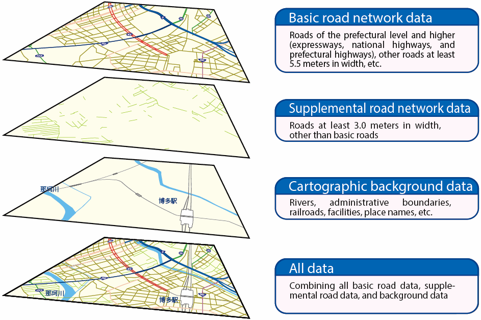
| Category | Data type | Contents (There are also additional data items for use by road administrators.) |
|---|---|---|
| Header | Header | Secondary grid cell codes (see Note 1), base map used, earth’s magnetic declination, actual cell perimeter lengths, date each datum was updated, etc. |
| Basic road network data | Node data of basic road network | Node ID, location coordinates, node type, number of connecting links, connecting node IDs, intersection name, number and destinations of connecting ferry routes, etc. |
| Link data of basic road network | Link ID (node ID numbers of each end), administrator code, road type, route number, overlapped route information, municipal area code, link length, width classification, condition of use, types of weather-related traffic restriction zones, vehicle weight, height and width restrictions, number of lanes, carriageway width, width of narrowest carriageway portion, median width, median extension length, 12-hour traffic volume, travel speed (at peak times), speed limit and other traffic regulations, coordinates of interpolation point locations, etc. | |
| Feature data of tunnel, bridge and so on | Location within basic road link, name, length, etc. of structures such as a bridge, elevated highway, tunnel, avalanche tunnel, grade crossing, pedestrian overpass, toll gate, and so on. | |
| Beacon location data | Beacon type, ID number, location, link IDs where the beacon is established, etc. | |
| Supplemental road network data | Node data of supplemental road network | Node ID number, location coordinates, node type, number of connecting links, connecting node IDs, intersection name, etc. |
| Link data of supplemental road network | Link ID number (node ID numbers of both ends), administrator code, road type, municipal area code, link length, width classification, number of lanes, traffic regulations, ID number of corresponding basic link, coordinates of interpolation point locations, etc. | |
| Railroad crossing feature data | Location within supplemental road link, name and length of railroad crossing, etc. | |
| Cartographic background data | Hydrographic data | Shorelines of sea, lake, river (polygon) or stream (polyline) |
| Administrative boundary data | Administrative boundaries of prefectures and municipalities including the wards of Tokyo and ordinance designated cities (polyline) | |
| Railroad location data | Railroad type, location, and underground conditions | |
| Location data for facilities, etc. | Location, municipal area code, name, etc. of facilities such as a local government office, service area, parking area, roadside rest area, ferry terminal, railroad station, or airport | |
| Configuration data of facilities,etc. | Outline of a large-scale railroad station, airport, park, etc. (polygon) | |
| Place name data | Place name, display level reference code, display reference location coordinates and angle, municipal area code, and other data concerning administrative names (city, town, village, ward, etc.), feature names (island, cape, shore, etc.) and road facility names (interchange, harbor, sign, destinations, etc.) |
- Notes:
- 1. A national standard regional grid cell of about 10 x 10 kilometer squares.
- 2. Some data may not yet have been stored for certain types of roads or in certain regions.
- 3. The content described in this table is based on the National Digital Road Map Database Standards